

PUB. 171
SAILING DIRECTIONS (ENROUTE)
EAST AFRICA
AND THE
SOUTH INDIAN OCEAN
Prepared and published by the NATIONAL GEOSPATIAL-INTELLIGENCE AGENCY
Springfield, Virginia
© COPYRIGHT 2020 BY THE UNITED STATES GOVERNMENT NO COPYRIGHT CLAIMED UNDER TITLE 17 U.S.C.
2020
FOURTEENTH EDITION

II
Preface
Pub. 171, Sailing Directions (Enroute) East Africa and the South Indian Ocean, Fourteenth Edition, 2020, is issued for use in conjunction with Pub. 160, Sailing Directions (Planning Guide) South Atlantic Ocean and Indian Ocean. The companion volumes are Pubs. 172, 173, 174, and 175.
Digital Nautical Chart 2 provides electronic chart coverage for the area covered by this publication.
This publication has been corrected to 26 September 2020, including Notice to Mariners No. 39 of 2020. Subsequent updates have corrected this publication to 22 January 2022, including Notice to Mariners No. 4 of 2022.
Explanatory Remarks
Sailing Directions are published by the National GeospatialIntelligence Agency (NGA) under the authority of Department of Defense Directive 5105.60, dated 29 July 2009, and pursuant to the authority contained in U. S. Code Title 10, Chapter 22, Section 451 and Title 44, Section 1336. Sailing Directions, covering the harbors, coasts, and waters of the world, provide information that cannot be shown graphically on nautical charts and is not readily available elsewhere.
Sailing Directions (Enroute) include detailed coastal and port approach information which supplements the largest scale chart produced by the National Geospatial-Intelligence Agency. This publication is divided into geographic areas called “Sectors.”
Bearings.—Bearings are true, and are expressed in degrees from 000° (north) to 360°, measured clockwise. General bearings are expressed by the initial letters of the points of the compass (e.g. N, NNE, NE, etc.). Adjective and adverb endings have been discarded. Wherever precise bearings are intended, degrees are used.
Charts.—Reference to charts made throughout this publication refer to both the paper chart and the Digital Nautical Chart (DNC).
Corrective Information.—Users should refer corrections, additions, and comments to NGA’s Maritime Operations Desk,  as follows:
NGA Maritime—Contact Information
Maritime Operations Desk
|
Toll free |
|
1-800-362-6289 |
|
|
||
|
|
|
|
|
Commercial |
|
571-557-5455 |
|
|
||
|
|
|
|
|
DSN |
|
547-5455 |
|
|
||
|
|
|
|
|
|
navsafety@nga.mil |
|
|
|
||
|
|
|
|
|
|
Maritime Safety Office |
|
|
|
||
|
|
|
|
|
DNC web site |
|
https://dnc.nga.mil |
|
|
||
|
|
|
|
NGA Maritime—Contact Information
MaritimeDomain |
https://msi.nga.mil |
web site |
|
|
|
MarHelp@nga.mil |
|
|
|
Maritime Quality |
https://marhelp.nga.mil |
Feedback System |
|
(MQFS) |
|
|
|
Mailing address |
Maritime Safety Office |
|
National Geospatial-Intelligence |
|
Agency |
|
Mail Stop N64-SFH |
|
7500 Geoint Drive |
|
Springfield VA 22150-7500 |
|
|
New editions of Sailing Directions are corrected through the date of publication shown above. This publication is updated as needed and made available as a downloadable corrected publication on the NGA Maritime Safety Office web site.
NGA Maritime Safety Office Web Site
https://msi.nga.mil
Courses.—Courses are true, and are expressed in the same manner as bearings. The directives “steer” and “make good” a course mean, without exception, to proceed from a point of origin along a track having the identical meridional angle as the designated course. Vessels following the directives must allow for every influence tending to cause deviation from such track, and navigate so that the designated course is continuously being made good.
Currents.—Current directions are the true directions toward which currents set.
Distances.—Distances are expressed in nautical miles of 1 minute of latitude. Distances of less than 1 mile are expressed in meters, or tenths of miles.
Geographic Names.—Geographic names are generally those used by the nation having sovereignty. Names in parentheses following another name are alternate names that may appear on some charts. In general, alternate names are quoted only in the principal description of the place. Diacritical marks, such as accents, cedillas, and circumflexes, which are related to specific letters in certain foreign languages, are not used in the interest of typographical simplicity.
Geographic names or their spellings do not necessarily reflect recognition of the political status of an area by the United States Government.
Heights.—Heights are referred to the plane of reference used for that purpose on the charts and are expressed in meters.
Internet Links.—This publication provides Internet links to web sites concerned with maritime navigational safety, including but not limited to, Federal government sites, foreign Hy-
Pub. 171
III
drographic Offices, and foreign public/private port facilities. NGA makes no claims, promises, or guarantees concerning the accuracy, completeness, or adequacy of the contents of these web sites and expressly disclaims any liability for errors and omissions in the contents of these web sites.
International Ship and Port Facility Security (ISPS) Code.—The ISPS Code is a comprehensive set of measures to enhance the security of ships and port facilities developed in response to the perceived threats to ships and port facilities in the wake of the 9/11 attacks in the United States. Information on the ISPS Code can be found at the International Maritime Organization web site:
International Maritime Organization Home Page
http://www.imo.org
Lights and Fog Signals.—Lights and fog signals are not described, and light sectors are not usually defined. The Light Lists should be consulted for complete information.
National Ocean Claims.—Information on national ocean claims and maritime boundary disputes, which have been compiled from the best available sources, is provided solely in the interest of the navigational safety of shipping and in no way constitutes legal recognition by the United States. These nonrecognized claims and requirements may include, but are not limited to:
1. A requirement by a state for advance permission or notification for innocent passage of warships in the territorial sea.
2.Straight baseline, internal waters, or historic waters claims.
3.The establishment of a security zone, where a state claims to control activity beyond its territorial sea for security reasons unrelated to that state’s police powers in its territory, including its territorial sea.
Radio Navigational Aids.—Radio navigational aids and ra-
dio weather services are not described in detail. Publication No. 117 Radio Navigational Aids and NOAA Publication, Selected Worldwide Marine Weather Broadcasts, should be consulted.
Soundings.—Soundings are referred to the datum of the charts and are expressed in meters.
Telephone and Facsimile Numbers.—Within this publication, the international telephone and facsimile numbers provided as contact information contain the minimum digits necessary to dial. Please note that these contact numbers do not include additional digits or special characters, such as (0) or (+), which may be required when dialing. The necessity of such digits and characters depend upon numerous factors and conditions, such as the user’s geolocation and service provider.
Mariners are advised to consult their communications equipment and service provider manuals for guidance.
Time.—Time is normally expressed as local time unless specifically designated as Universal Coordinated Time (UTC).
Standard Time Zone of the World Chart
https://www.cia.gov/maps/world-regional
Time Zone.—The Time Zone description(s), as well as information concerning the use of Daylight Savings Time, are included. The World Time Zone Chart is available on the Internet at the web site given above.
U.S. Maritime Advisory System.—The U.S. Maritime Advisory System is a streamlined inter-agency approach to identifying and promulgating maritime security threats. The system replaces Special Warnings to Mariners (State Department), MARAD Advisories (Maritime Administration), and Marine Safety Information Bulletins (U.S. Coast Guard) and consists of the following items:
1. U.S. Maritime Alert—Provides basic information (location, incident, type, date/time) on reported maritime security threats to U.S. maritime industry interests. U.S. Maritime alerts do not contain policy or recommendations for specific courses of information.
2. U.S. Maritime Advisory—Provides more detailed information, when appropriate, through a “whole-of-gov- ernment” response to an identified maritime threat.
Maritime Administration (MARAD)—U.S.
Maritime Advisory System
https://www.marad.dot.gov/environment-and-safety/ office-of-security/msci
Winds.—Wind directions are the true directions from which winds blow.
Reference List
The principal sources examined in the preparation of this publication were:
British Hydrographic Department Sailing Directions. French Hydrographic Service Sailing Directions.
Reports from United States naval and merchant vessels and various shipping companies.
Other U.S. Government publications, reports, and documents.
Charts, light lists, tide and current tables, and other documents in possession of the Agency.
|
Date of Change: |
22 January 2022 |
|
|
|
|
|
||
|
Notice to Mariners: 4/2022 |
|
||
|
|
|
|
|
|
Sector |
|
Paragraphs |
|
|
|
|
|
|
|
Sector 2 |
|
Paragraphs 2.3, 2.5, 2.21, and 2.37 |
|
|
|
|
|
|
|
Sector 3 |
|
Paragraph 3.36 |
|
|
|
|
|
|
|
|
|
|
|
Pub. 171
Date of Change: |
22 January 2022 |
|
|
||
Notice to Mariners: 4/2022 |
||
|
|
|
Sector |
|
Paragraphs |
|
|
|
Sector 5 |
|
Paragraph 5.7 |
|
|
|
Sector 6 |
|
Paragraph 6.17 |
|
|
|
Sector 7 |
|
Paragraph 7.9 |
|
|
|
Sector 9 |
|
Paragraphs 9.11 and 9.43 |
|
|
|
Sector 10 |
|
Paragraph 10.30 |
|
|
|
Date of Change: |
28 August 2021 |
|
|
||
Notice to Mariners: 35/2021 |
||
|
|
|
Sector |
|
Paragraphs |
|
|
|
Sector 1 |
|
Paragraph 1.18 |
|
|
|
Sector 2 |
|
Paragraphs 2.23 and 2.38 |
|
|
|
Sector 3 |
|
Paragraph 3.36 |
|
|
|
Sector 5 |
|
Paragraph 5.7 |
|
|
|
Sector 6 |
|
Paragraph 6.17 |
|
|
|
Sector 7 |
|
Paragraphs 7.17 |
|
|
|
Sector 11 |
|
Paragraph 11.28 |
|
|
|
Date of Change: |
1 May 2021 |
|
|
||
Notice to Mariners: 18/2021 |
||
|
|
|
Sector |
|
Paragraphs |
|
|
|
Sector 1 |
|
Paragraph 1.18 |
|
|
|
Sector 2 |
|
Paragraphs 2.3, 2.5, 2.11, 2.23, 2.28, and 2.37 |
|
|
|
Sector 3 |
|
Paragraph 3.36 |
|
|
|
Sector 5 |
|
Paragraphs 5.7. 5.16, and 5.17 |
|
|
|
Sector 6 |
|
Paragraph 6.17 |
|
|
|
Sector 7 |
|
Paragraphs 7.2, 7.7, and 7.9 |
|
|
|
Sector 8 |
|
Paragraphs 8.9 and 8.18 |
|
|
|
Sector 9 |
|
Paragraphs 9.2, 9.6, 9.7, 9.8, 9.9, 9.12, 9.14, 9.31, 9.35, 9.40, 9.43, and 9.45 |
|
|
|
Sector 10 |
|
Paragraphs 10.25, 10.30, 10.42, and 10.43 |
|
|
|
Sector 11 |
|
Paragraph 11.28 |
|
|
|
V
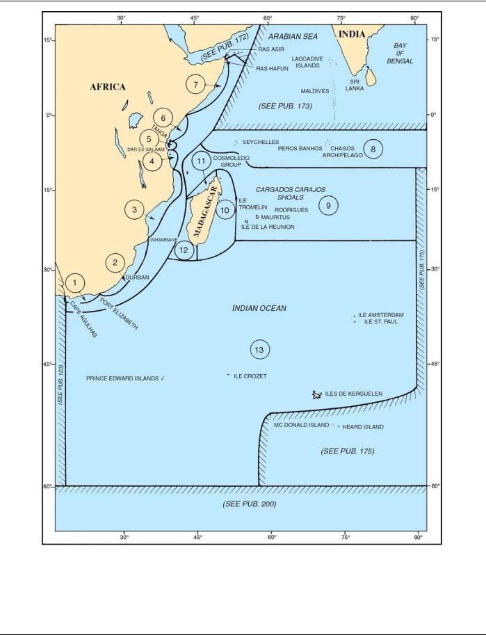
SECTOR LIMITS—PUB. 171
Pub. 171